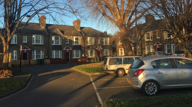
Atlas and Derrick Gardens would become part of a conservation area under the new plans
There’s a week left if you want to comment on Greenwich Council plans to create new conservation areas by the riverside at Charlton.
Two new areas are planned – one to protect the housing at Atlas and Derrick Gardens, the Anchor & Hope pub, Vaizeys Wharf and the Corys barge works; the other to protect areas around the Thames Barrier such as the old Victoria pub, the former Siemens works, and surviving parts of the old Woolwich Royal Dockyard.
The council also wants to locally list several buildings in the area, from the 1985 East Greenwich fire station (“an example of late 20C public sector design”) to Stones Foundry and Windrush Primary School.
The former Clancy’s pub at the end of Warspite Road is also scheduled for listing, under its original name of the Lord Howick.
Crowds watching April’s Tall Ships Regatta from in front of the development site
A property developer has revealed plans for a 25-storey tower for land next to the Thames Barrier – flying in the face of Greenwich Council’s proposed new masterplan for the Charlton riverside.
Komoto Group Limited wants to redevelop the site to the west of the Barrier to provide 570 homes plus commercial and retail space and up to 500 car parking spaces.
The company owns the site, which is currently home to the Raceway go-kart track, Bunker 51 laser-tag centre, a church, and other firms. The land was formerly home to the Johnsen & Jorgensen glass works, which closed in 1981.
But the plans directly contradict Greenwich’s proposed new masterplan for the area, which envisages mostly low to medium-rise developments of up to 10 storeys. There is a get-out plan which would permit taller buildings if there is “adequate public transport”, which certainly does not apply here.
However, the masterplan has not yet been legally adopted, so Komoto is clearly hoping to squeeze this through before then. The company is currently asking for a “scoping opinion” – an early opinion from the council’s planners on what the main issues with the development are likely to be.
The consultation into the Charlton Riverside masterplan closed last week. The big plan was to write something a few weeks back picking out a few interesting things from the three chunky documents that make up the masterplan. Then real life intervened.
But it’s still worth a canter through the masterplan – because if you plan to stick around in or near Charlton over the next decade or so, this will affect you. It’s actually a thoughtful document with much going for it. Huge developments are now springing up on the Greenwich Peninsula, in Woolwich, and across the water at Silvertown, where residents of Royal Wharf will have a lovely view of the Anchor & Hope. Now it’s our turn.
The plan is for 5,000-7,500 new homes (50% family housing, 35% “affordable”), mostly low to medium rise (3-6 storeys) developments, 4,000 additional jobs, expanding the park at the Thames Barrier and linking it to Maryon Park, and downgrading Woolwich Road west of Anchor & Hope Lane. Activity will start first nearer the barrier – but this will be is a very long-term process.
The first point to note is that this is a slightly broader area than Charlton itself – it stretches to Horn Lane, at the edge of east Greenwich, to take in the wharves and freight railway line; but stopping just short of the extended Greenwich Millennium Village and proposed Ikea. To the west, it goes out to Warspite Road in Woolwich, while the heritage study goes further into the old Woolwich royal dockyard site.
The second point is that this marks a change in approach by Greenwich Council. And this isn’t just in recommending fairly low-rise development – up to ten storeys. Past masterplans have effectively been left to the market – the Greenwich Peninsula masterplan was essentially written by the lead developer, Knight Dragon; Berkeley Homes effectively controls the Woolwich waterfront east of the ferry.
But here, Greenwich is seeking to take a more active role in starting development. Whether this is an acknowledgement of recent mistakes or a reaction to a different set of circumstances, it doesn’t say, although part of it is about making sure the risk of flooding around the Thames Barrier – where the council is keen to get things started – is properly dealt with.
Indeed, there’s already a threat to the draft masterplan in the Rockwell plan for Anchor & Hope Lane – 28 storeys rather than ten. But there is a get-out clause – ““tall buildings may be appropriate so long as there is adequate public transport and consideration is given to existing historical assets and distinctive characteristic features”. Does this apply on Anchor & Hope Lane?
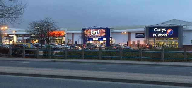
For Woolwich’s shops to live again, Charlton retail must die?
Retail barns in Charlton aren’t a new thing – the first to open was Makro, in March 1974. (Sainsbury’s got a foothold before that, opening its original depot up the road four years earlier.)
They’ve even begun to cannibalise themselves – the Greenwich Shopping Park and Sainsbury’s/M&S sit on the sites of 1980s retail/industrial units, as will the delayed Brocklebank Retail Park, due to open later this year.
None of it is safe under the masterplan – “the existing retail does not conform with [council] policy”, it says, even if these sites were only given permission a few years ago. Few councillors representing Greenwich’s strand of the Labour party will apologise for allowing development that they think will allow employment, even if it’s at the expense of the surrounding environment. But Greenwich’s planners must now be hoping Charlton has hit Peak Retail.
You don’t have to look too far to sense an ulterior motive – the long decline of Woolwich as a shopping area, for which one culprit is the retail barns in Charlton. As long ago as the early 1980s, Greenwich objected to Asda coming here because it wanted to protect Woolwich, and as recently as 2011, Woolwich Riverside councillor John Fahy made the same complaints about the relocated Sainsbury’s store.
Greenwich councillors still hanker after Woolwich being designated a “metropolitan centre”, like Bromley or Stratford. Instead, it’s a “major centre”, along with Eltham, Lewisham, Catford, Canary Wharf and Bexleyheath. The GLA agrees Woolwich could be bumped up a league – which would delight councillors eager to get one over the old enemy in Bexley. One way to achieve that could be for some of that retail floorspace to leave Charlton and return to SE18.
In any event, the retail can adapt to survive – homes and offices can always be built on top of retail premises, just as Tesco did in Woolwich. In Hackney, the council is buying the area’s Tesco superstore to redevelop it while keeping space for the supermarket. Could a project like this come to Charlton?
Balancing employment, heritage and housing – an impossible ask?
Think you know Charlton’s riverside? Think again. I guarantee you will learn something new if you leaf through the heritage and employment study, which contains fascinating case studies of the businesses on our doorstep.
5,600 people are employed by the river and the plan is to keep it that way. But with many in manufacturing (18% of businesses) and vehicle repair (13%), how many of these can remain? The Blackwall Tunnel is seen as both a blessing and a curse by many firms – but with increased pressure on the road network, it’s hard to see how these can co-exist with mass homebuilding.
To the west, Angerstein and Murphy’s wharves are assumed to be staying in use – should the businesses close, the study suggests the railway line alignment leading to the yards is kept for possible passenger use.
The idea here seems to be to develop the artistic and creative uses that have developed around Thames-Side Studios. But with public transport access fairly poor, is this really a goer?
But there’s a strong emphasis on making more of the rich history of the Charlton riverside, possibly a reaction to the near-complete erasure of much of Greenwich Peninsula’s industrial heritage.
Buildings recommended for listing include somes of the old Siemens buildings (partly used by Thames-Side Studios) and the Corys boatyard – even though the council gave the firm permission to knock it down four years ago. It’s suggested the Victoria pub facade is retained and the site put to a new use. Interestingly, the surviving small shop on the north side of Woolwich Road – London & Kent Electrical, whose owner refused to move when the Sainsbury’s/M&S site was being developed – is also recommended for listing.
One thing missing from the heritage study is the area’s sporting links – a huge omission is the founding of Charlton Athletic at Siemens Meadow, in the heart of the area now up for redevelopment, in 1905. There is also no mention of the greyhound stadium which sat on Anchor & Hope Lane from 1928 to 1971.
It’s all about the infrastructure
The Greenwich Waterfront Transit was scrapped,
but its East London sister service survives in Dagenham and Ilford (Photo from Julian Walker via Creative Commons CC BY-NC-ND 2.0)The weakest part of the masterplan is – as ever – the infrastructure part. There are positive parts – reworking Bugsbys Way to make it less of a barrier desperately needs doing now, and it’s good to see it get a mention. (Interestingly, Barking & Dagenham is planning to bury the A13 for a stretch to encourage redevelopment – would this be a goer in Charlton or the peninsula, or just it just hide a problem?)
The plan sees a new road being driven through from Anchor & Hope Lane towards Woolwich Road to serve the new developments – but this would not be an alternative to Woolwich Road, which seems peculiar when one of the wishes of the masterplan is to see part of the A206 downgraded so it only serves local traffic. Instead, it would be used by a revived Greenwich Waterfront Transit, the segregated bus scheme axed by Boris Johnson in 2008.
But with North Greenwich station due to come under increasing pressure – and the Greenwich Peninsula itself to get more crowded – expecting or encouraging people to commute via there may be an unrealistic ask. It’s hard to know quite what the answer is, though, without getting a crayon out and drawing a line that will cost billions.
There are more fundamental flaws than this – there’s nothing about linking the riverside to north of the river beyond suggesting a riverboat pier; a study by architect Terry Farrell last year proposed a low, lifting bridge for public transport, pedestrians and cyclists for roughly Anchor & Hope Lane – that doesn’t feature. Nor is there anything about relocating Woolwich Dockyard station, which would enable the platforms to be lengthened and for it to better serve the regeneration area.
Woolwich Road wonders
There are big dreams for Woolwich Road. “The aim is to create a high quality and attractive urban boulevard shared by pedestrians, cyclists and vehicles with improved connectivity between the riverside area and the existing community of Charlton.”
But improvements to Woolwich Road are – in the short term at least – being stymied by the mayor’s office: Sadiq Khan’s TfL budget cuts mean the planned Cycle Superhighway 4, due to run to Woolwich, will only go as far as Greenwich town centre by 2020. Greenwich was hoping to use this to fix some of the A206’s lethal junctions at east Greenwich and Anchor & Hope Lane; we’ll now have to wait.
There are two set-piece ideas suggested: one is to replace long-standing plans for a “green bridge” across Woolwich Road at Maryon Park with a “green crossing”. This would be cheaper and would calm the traffic on Woolwich Road down, providing a safer way for children at nearby schools to cross the road.
The other looks at the bus terminal outside Charlton station, originally constructed in 1999 for Millennium Dome buses. The report suggests it could return to being green space or find some other use – but this glosses over the fact that it’s still used by short-running buses and rail replacement services. It would also kibosh local lobby group Transport for Charlton’s desire to have the 472 loop around here to serve Charlton station.
So what happens next?
Now the consultation is over, Greenwich Council will amend the masterplan to incorporate anything which comes up that it agrees with, then it’ll become a part of the local planning framework, and it’ll be used to guide development in the area over the coming years. We’ve been talking about the riverside for years, but it finally looks like things are about to happen down there.
These are always difficult processes – a masterplan requires you to think big, but local councils only have so much power. And even though Charlton Riverside is on City Hall’s radar, will a skint Transport for London be able to deliver the improvements needed to help it flourish?
We’ll have to see what happens with the Rockwell Anchor & Hope Lane plan – if that gets through, the plan for Charlton Riverside may end up being just that, a plan, as developers make hay. It may not seem that way when you wander down by the river, but the next year or so is going to be be crucial in terms of deciding what will happen down there.
Greenwich Council formally launched the Charlton Riverside masterplan consultation last week. We hope to publish more on what’s inside over the next couple of weeks, but there are council consultation sessions over the next month where you can ask questions and make comments.
Sessions are being held at The Valley, Charlton House, Greenwich Trust School and New Charlton Community Centre between 4 and 22 March.
In true local paper style, here’s the council’s press release…
Residents are being invited to participate in our consultation on the proposed Charlton Riverside development.
Charlton Riverside is an exciting opportunity for a mixed use neighbourhood, characterised by medium-rise development. The proposed development will continue to be an important employment area, which could add space for around 5,000 more jobs, as well as up to 7,500 new homes, schools, open space and community health facilities.
Future development could integrate modern, clean, hi-tech business and industrial with residential and community uses to create a dynamic living and working environment.
Consultation drop in sessions will also be held on the following dates where people can ask questions and make comments on the proposals:
Saturday 4 March: Charlton Athletic, Floyd Road, SE7 8BL from 10am to 12pm Tuesday 7 March: Charlton House, Charlton Road, SE7 8RE from 1pm to 3pm Tuesday 14 March: Royal Greenwich Trust School, 765 Woolwich Road, London SE7 8LJ from 7pm to 9pm Wednesday 22 March: New Charlton Community Centre, 217 Maryon Road, Charlton SE7 8DB from 7.30pm to 9.30pm
Deputy Leader and Cabinet Member for Regeneration and Sustainability, Councillor Danny Thorpe, said: “The proposed Charlton Riverside development respects the industrial heritage of Charlton Riverside, natural environment and local community aspirations while delivering the new homes, businesses and thousands of jobs required.
“Working with and for residents and businesses is central to making Charlton Riverside successful, which is why we are asking local people to come along to next month’s meetings and have their say on our proposals.”
The consultation starts on 22 February and will remain open to receiving any written or email comments by 5pm on 12 April. To give us your views, please go online to: www.royalgreenwich.gov.uk/haveyoursay
Alternatively, you can give us your comments by letter to:
Regeneration Team, Fifth Floor, The Woolwich Centre, 35 Wellington Street, Woolwich, London SE18 6HQ
Or by email to: charlton-masterplan[at]royalgreenwich.gov.uk.
If you want to find out more about the plans to redevelop Charlton’s riverside industrial land, then there’s a “stakeholder forum” on Wednesday 1 February at 7.30pm at the Old Library in Charlton House.
Greenwich Council deputy leader Danny Thorpe will be updating attendees on the borough’s slow progress on rewriting the Charlton Riverside Masterplan, which is running a year late and is widely believed to be ditching plans for it to follow the “principles of a garden city” in favour of riverside tower blocks.
Ripe for development: Charlton’s riverside at the Thames Barrier
One of the developers behind the redevelopment of Charlton’s riverside is promising “affordable homesteads for ordinary people alongside the river Thames” as part of a plan to create 5,000 new homes on what is currently industrial land.
Richard Upton, deputy chief executive of U+I, says the company will soon be in control of enough land to create a “small town” by the Thames.
Upton’s statement pre-empts a Greenwich Council consultation on a new masterplan for the riverside, which has been postponed until after the mayoral election.
His comments appear in Historic England’s Conservation Bulletin (see pages 26-28), in a special edition devoted to the challenges London’s next mayor will face.
Under U+I’s previous name of Cathedral, the company was responsible for the Movement development next to Greenwich station as well as the redevelopment of the Eltham Coronet cinema site. U+I is also behind Deptford Market Yard, next to Deptford station, and owns the Morden Wharf site to the west of the Greenwich Peninsula.
It’s the first official confirmation that U+I is involved in the plans for Charlton.
Upton writes: “In Charlton, U+I will soon control sufficient land to create a small town spanning 6 million square feet and providing 5,000 homes. The site is brownfield and light industrial in nature, but we’ve delved into its past and from this, we’ll create a future that makes it unique. The grimy industrial routes actually reflect the patterns of paths and hedgerows from the 17th century. Lovely. I promise you we will bring history and parochial distinction alive.
“Charlton will once again provide affordable homesteads for ordinary people alongside the river Thames.”
It also looks like architectural practice Farrells is also involved in the scheme. The article also features a timeline of the Charlton riverside’s history which is credited to Farrells.
This looks very like Anchor & Hope Lane… (picture: Farrells)
Earlier this year, founder Terry Farrell told the Evening Standard he wanted to see a series of low-rise lift bridges for pedestrians and cyclists across the Thames at locations including Rotherhithe, Greenwich Peninsula, Charlton and Woolwich.
The story was illustrated by a mock-up of such a bridge – which appears to be at the end of Anchor and Hope Lane in Charlton. Last year, TfL identified Charlton as a site for a potential crossing in a speculative list of 13 possible or planned links across the Thames, although it said the idea was merely “conceptual”.
Separately, plans to create a secondary school on the riverside could come to fruition much earlier than planned, with proposals for the two-year-old Royal Greenwich University Technical College to become an 11-18 school, after the college had trouble recruiting students at age 14. A little-publicised consultation took place earlier this year.
Charlton Asda: This site could be zoned for housing under a Greenwich Council plan
The area around Charlton’s Asda superstore could be earmarked for housing under plans being consulted on by Greenwich Council.
We’re still waiting to hear what the council has up its sleeve for redeveloping Charlton’s riverside – plans to reveal a new Charlton Riverside Masterplan have been postponed until the spring.
But you can find a few clues about what’s going on in the snappily titled Greenwich Local Plan Site Allocations consultation. It’s not being very well publicised, but it’s happening now and will have a bearing on the future development of Charlton and the wider borough of Greenwich.
This is about allocating particular sites in the borough for particular uses. For example, the unbuilt plots at Greenwich Millennium Village are allocated for housing.
Much of the focus is on Charlton’s riverside area – and that includes the possibility of converting much of SE7’s retail space into housing and community uses.
The Asda site, together with the retail parks and industrial premises that surround it, are part of one area suggested for “residential, non-retail commercial/employment uses, community infrastructure including open space, and an area of search for schools”.
“Current uses are out of-town retail, threatening growth of retail development in other centres,” the consultation says – a not-very-subtle way of saying Woolwich’s development as a shopping centre is being throttled by Charlton’s retail parks.
The effect of Charlton’s retail parks on Woolwich has been a running sore with Greenwich Council for decades. Big box retail first came to Charlton in the 1970s when Makro – aimed at business customers – opened on the site of the old greyhound stadium.
In the early 1980s, Greenwich Council originally refused permission for Asda to open its Charlton store, but was overruled by a planning inspector. Local newspapers at the time reported that plans for a new Co-op store, which would have been the centrepiece of a redeveloped Woolwich town centre, would be axed if Asda went ahead. It’s pretty much undeniable that Woolwich entered a long period of decline from about that time.
Since those early days, retail parks have opened across the Charlton riverside area – with the council’s blessing. The latest – an extension to the misleadingly-named Greenwich Shopping Park – is under construction.
It now appears the council is trying to turn back the tide. The plans don’t affect the retail parks’ ability to trade from their existing sites. But expansion or replacement could be more difficult – and selling up for housing could be more lucrative.
Charlton’s riverside has changed since this photo was taken, and is set for more changes
There’s a useful interactive map on the Greenwich Council website – here’s the plans as they affect Charlton and immediately adjacent areas.
Charlton Riverside West (Asda, Ramac industrial estate, surrounding retail parks): “Residential and area of search for schools.”
Charlton Riverside North West Industrial (north of Makro): “Industrial uses compatible with PIL (SIL) and area of search for Waste facility to include a Vacuum Waste Collection Centre and a Reuse and Recycling Centre.”
Charlton Riverside Central (Makro, Stone Lake Retail Park, Stones Foundries, Penhall Road) “Residential, small scale retail, employment use. Seconday and primary school area of search. To include bus and cycle east-west route and transport interchange at the south western corner of the site opposite Charlton Church Lane.”
Thames Barrier approach and Eastmoor Street (car breakers’ yards, etc): “Community open space to include playing pitch which could be dedicated for school use, replacing playing pitch north of UTC building if the existing playing pitch is needed for school expansion.” (A neighbouring zone, Charlton Educational, covers Windrush Primary School and the Greenwich University Technical College.)
Land to the south of Thames Barrier: “Safeguarding for Flood Defences, only a use compatible with this is to be considered, such as Community Open Space.”
Harrington Way (area around Second Floor Arts): “Existing historic buildings to be retained and used for B1, offices , creative uses, studios in accordance with IBP designation.”
Westminster Industrial Estate (immediately to east of Thames Barrier site): “Existing historic buildings to be retained and used for B1, offices , creative uses, studios.”
Morris Walk, Maryon Grove estates:“Redevelopment for improved quality and intensification of residential uses” – which looks like this little-publicised 13-storey tower planned for the site of the Albion pub on the Woolwich side of Morris Walk.
Maryon Road estates: “Redevelopment for improved quality.” No tower blocks, then.
40 Victoria Way (the one remaining warehouse from the old Thorn Lighting site): “Housing.” No surprise there.
This last one’s interesting – the Angerstein Triangle is an old railway yard (there’s still a set of steps linking it to Westcombe Park station) that was once proposed as the terminal for what became the Jubilee Line extension. Perhaps this is still sitting in planners’ minds. Charlton Champion reader Stephen Baycroft suggests it “should instead be rezoned into parkland and/or community facilities” to ease the pressure of lorries coming down residential streets.
Finally, both The Valley and the Rectory Field remain zoned as community open space under the proposals.
Naturally for a set of council proposals that directly affect Charlton, none of the roadshows for the scheme are taking place here.
Instead, you can talk to planners at the Greenwich Centre on Saturday 27 February from 2pm-5pm, and at the Woolwich Centre on Thursday 3 March from 4pm-7pm. More details on the Greenwich Council website.